Cross-Section Editor
This module enables you to perform your cross-sectional design and calculation tasks. All editing is done in the graphics, starting with the design of cross-sections right through to the determination of volumes. Any existing width strings, cross-fall strings and vertical alignments can be used as planning aids.
If required, you can obtain a 3D effect by taking the neighbouring chainages into account when deciding on design issues.
You can also interactively calculate the cross-section volumes and you can output these volumes together with the individual values. more >
Cross-Section Design / 3D Route Structures / Cross-Section Design (Rail)
Automatic development of cross-sections, surface elevation list. Basic system of smart infra-modelling technology for parameterised, rule-compliant and technical development of 3D route structures for roads, motorways, footpaths and cycle paths; generation of roadways without junctions and intersections; simple design of roadsides. Requires the Cross-Section Editing module.
Cross-Section Transformation
This module enables you to transform and move cross-sections. The cross-section lines are transformed so that they retain their original approximate plan position.
Moving cross-section lines is useful if the chainages of the alignment originally used have had to be modified during the design process. The use of this function eliminates the need to create new cross-sections at the modified chainages. This is especially useful if the cross-sections cannot be generated again, either because they were created manually or have been extensively revised. more >
Volumes from Cross-Sections
You can calculate volumes and surfaces from cross-sections according to the guidelines REB-VB 21.003 and REB-VB 21.013. Any data and parameters used to control a volume calculation are saved, thus enabling the calculation to be entirely checked and analysed at any time.
Cross-Section Drawing / Cross-Section Drawing (Rail)

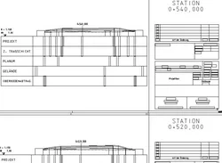
You can create cross-section drawings with individual sheet positioning, flexible annotation and design.
You can display and output surveying vehicles, road and rail furniture objects, trees and hedges. more >
Cross-Sections from Points
This module enables you to calculate cross section lines and longitudinal profile lines according to the guidelines REB-VB 20.003 from existing cross-sections and longitudinal profiles which have been surveyed as topographic points. more >
Cross-Sections from Lines
You can calculate alignment related cross-sections and longitudinal profiles from lines of the card_1 base map. This method is very convenient if the base map data provides sufficient information or the creation of a digital terrain model is not required or not possible; e.g. digitized contour lines. more >
Base Map from Cross-Sections
You can import the relevant cross-sectional information, e.g. points, lines and slopes into the base map.
